Eko Atlantic
Victoria Island spent a century losing its beach. A wall fixed that. In 2012, a study initiated by the project’s own marine engineers modelled what the wall would do to the coast beyond it and found the erosion would shift eastward. The communities there say it did. The sand the model said would be needed every year to stop it is not something we can find any record of.
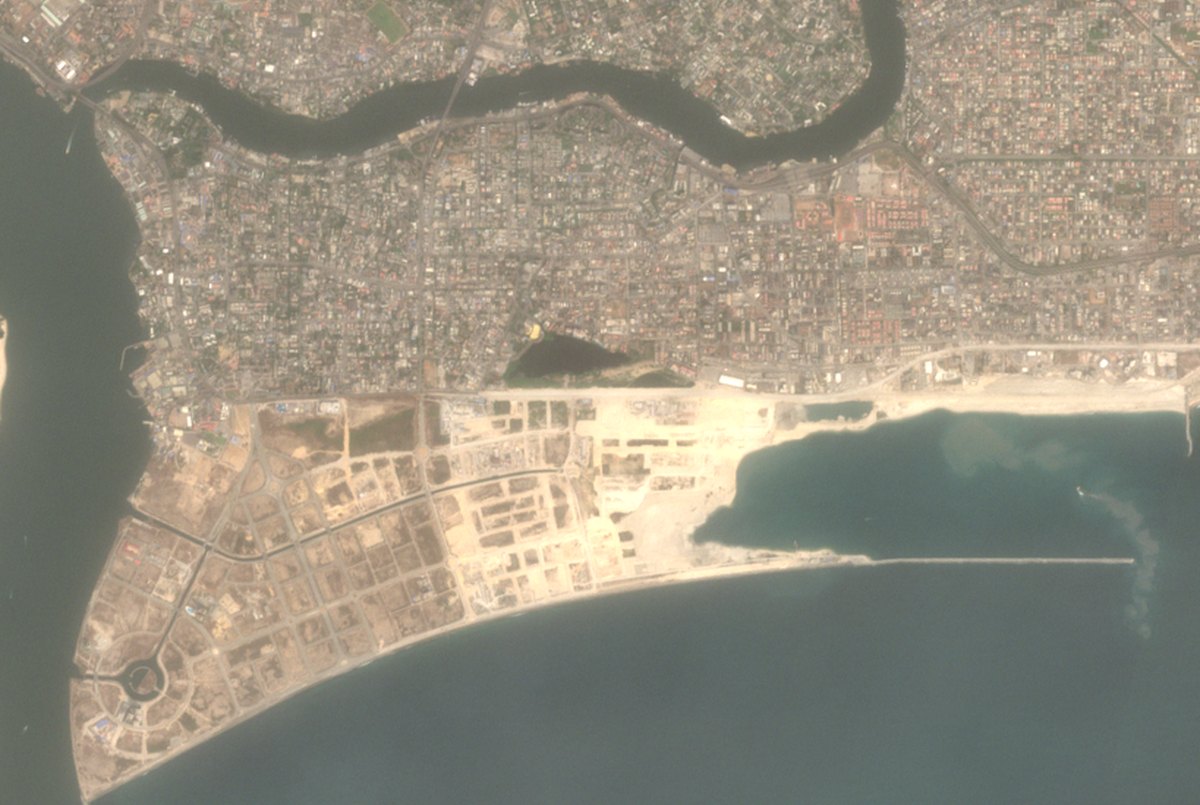
Sentinel-2 surface reflectance, 25 December 2024, true colour. Contains modified Copernicus Sentinel data 2024, processed by Sponge Media. Nothing has been added to or removed from the image.
There used to be a beach here. Then there wasn't.
Bar Beach was where Lagos went on a Sunday. It is not there now, and it did not go suddenly. — that figure comes from the marine engineers on the project that replaced it, and nobody argues with it.
Sand was trucked in for decades to hold the line, and the sea took that too. By the time anyone drew a plan for what is there now, the argument had already been settled by the water: .
So the first thing to be clear about is that the problem was real. Whatever you make of what was built here, it was built on a coast that was genuinely going.
A hundred thousand blocks, five tonnes each.
The thing holding the Atlantic off is a revetment, not a sea wall in the way most people picture one. It is a sloped bank of rock faced with interlocking concrete units that break a wave up rather than bouncing it back. .
, and it is meant to run . Behind it, dredgers pumped sand off the sea floor into a shape: .
Both of those numbers come from the people who built it. We have looked for an independent survey of the wall's length and the reclaimed area and have not found one.
A public coastline, solved privately.
The state did not build this. , and . The wall went up from 2009; a ceremony marking the start of reclamation followed in February 2013.
The arrangement is a straightforward trade, and it is worth stating plainly rather than disapprovingly: a private company takes on the cost and the risk of defending a shoreline, and in exchange it gets to own and sell the land it makes. The erosion problem becomes somebody's asset.
What the new ground is for is not a secret either. .
The concession agreement itself is not public so far as we can find, so the terms of that trade — what the state gave up, for how long, and on what conditions — are not something a reader can check. We are describing the shape of a deal from a government social media post and a tertiary source. .
That is a weaker footing than we would like for the central fact of who owns this coastline, and we would rather say so than write around it.
The communities on the other side say the water came for them.
Run your eye east along the coast in the picture above and the bays start. Past them is Okun Alfa, and past that is where Alpha Beach used to be. .
. The sequence is not disputed by anyone: dredging from 2008, the first big surge in 2009.
. . Five years later the same family told a different reporter the same thing: .
I lost my palace. The former palace is inside the ocean.
Something was built to stop it. . Where the barriers exist, people say they held.
Against the community’s account, the developer is unambiguous. .
And the state says the same. . His question is not a rhetorical one: something was eroding this coast long before anybody dredged anything, at 2 to 10 metres a year, and that process did not stop.
Somebody worked out what would happen. In 2012.
The argument on this coast is usually presented as community belief against engineering judgement, with nothing in between. There is something in between, and it has been sitting in a university repository, free to download, for fourteen years.
. It is a master’s thesis rather than a peer-reviewed paper, and it models a coastline rather than measuring one. Read it for what it is and it is still the most specific answer anybody has published.
Its finding has three parts, and the middle one is the part both sides leave out. . . So the model does not say the wall created the erosion. It says the wall concentrated it, worst nearest, easing with distance, spreading further along the coast as the years run.
. The study most often cited against Eko Atlantic was set going by the people engineering it, and published openly while the wall was still being built.
That matters because it rules out the easy dismissal. This is not an activist model. It came out of the same engineering world that designed the revetment, and it reached a conclusion the developer’s public materials do not mention.
It also said what to do about it. . Put plainly: to hold the coast east of the wall, somebody needed to be putting sand back, in the order of six hundred thousand cubic metres, every year, indefinitely.
We have looked for evidence that this happens, or has ever happened, and we have not found any. . Rock was put in instead of sand, and then the rock stopped.
The thesis is a prediction, and predictions are not measurements. . A model that leaves storm surges out is being used in an argument that is mostly about storm surges, and we are not going to pretend otherwise.
The government document people cite as proof is thinner than its reputation too. .
A second study is often listed alongside the Delft one — a 2014 physical model of Alpha Beach by Sojobi and colleagues. We read it and are not citing it. Its stated conclusion is that erosion from the hard works is “envisaged”, the Eko structure does not appear to have been in the model, its two empirical estimates of sediment transport differ from each other by about a factor of five without comment, and one printed density figure cannot be reconciled with its own result. It may well be pointing the right way. It does not carry weight.
So here is where it lands, and it is narrower than either side would like.
The wall protected Victoria Island. The erosion east of it was happening before and would have continued. A model initiated by the project’s own engineers said the wall would concentrate that erosion directly downdrift, and named the annual price of preventing it. Alpha Beach is gone, on the state’s own account. The people of Okun Alfa have been saying the same thing, in the same words, to anyone who turns up, since at least 2021.
. .
What nobody has produced — not the developer, not the state, not us — is a shoreline survey of this coast before and after, set against the model, to say how much of what happened is the wall and how much is the ocean doing what it was already doing. Fourteen years on, that is a choice, not an oversight.
A city built on ground that was not there.
Fifty-five seconds. Hidden in Plain Sight, from the Lagos chapter.
Read the filmEvery word on screen, in order.
Every day people work, live and build their futures along this coastline.
But there was a time when the ocean threatened what stood here.
Erosion threatened homes, businesses and the coastline around Victoria Island.
So the response was bigger than protecting the shore.
What if the threatened coastline could become land for an entirely new city?
Sand was dredged from the Atlantic to reclaim land.
And a massive sea defence was built to protect it.
This is Eko Atlantic, a city being built on land reclaimed from the ocean.
For the people building businesses, creating jobs and planning their futures here,
this is more than reclaimed land.
An ocean once taking land away now stands beside a city built to claim it back.
Made and paid for by Sponge Media. No sponsor on this film or this page.
Get the next one before anyone else.
One email when a new piece goes up. The working, the sources, and what we couldn't stand up. No more than that.
Subscribe on SubstackFree. Unsubscribe any time. We don't sell or share the list.
Where all of this came from
Every claim in the piece, with its source and its status. Nothing hidden in a footnote, including the things we haven't nailed down yet.
Royal Haskoning are the marine engineering consultants on the project. Kamau: “Various Nigerian and international searches show that the erosion rate of the Lagos coast, since as far as back 1910's… has been in the order of 2 to 10 meters per year.” The same statement says the land Eko Atlantic sits on “existed historically, but has eroded over a long period”.
https://www.ekoatlantic.com/blog/eko-atlantics-great-wall-of-lagos-passes-6km ↗
Caption to a satellite image on the developer's facts page: “Satellite image of the Commodore Channel in 2005 shows that Bar Beach no longer existed.” The same page says “The sand in this area was completely eroded.”
https://www.ekoatlantic.com/about/facts ↗
“The revetment uses a proven method of accropode units as primary armour.” “Each accropode is made on site and weighs 5 tons. 100,000 accropodes will be placed in a predefined grid.” The same post records the wall passing 6 km and says construction began in 2009.
https://www.ekoatlantic.com/blog/eko-atlantics-great-wall-of-lagos-passes-6km ↗
“Construction of the Great Wall of Lagos, which can be seen from space, began in 2009.” A ceremony marking the start of land reclamation was held on 21 February 2013, which is a different event and is sometimes reported as the start of the project.
https://www.ekoatlantic.com/blog/eko-atlantics-great-wall-of-lagos-passes-6km ↗
“The Great Wall of Lagos, reaching a total of 8.5km in length when completed, has already achieved its primary goal of protecting Victoria Island from Coastal Erosion.” Published figures elsewhere differ: Wikipedia's text gives a revetment “around 8.4 km” and, citing a 2016 source, “Seven kilometers of revetment will also be built”. We use the developer's own number and note the spread.
https://www.ekoatlantic.com/about/facts ↗
Frame refers to “everyone living and working within the ten square kilometres of reclaimed land”. Published figures disagree: Wikipedia's text says the project “involves reclaiming 9 km²” while its infobox gives a land area of 10 km², and a 2026 report citing EnvironewsNigeria puts it at about 9 km² built with roughly 95 million cubic metres of sand.
https://www.ekoatlantic.com/blog/eko-atlantics-great-wall-of-lagos-passes-6km ↗
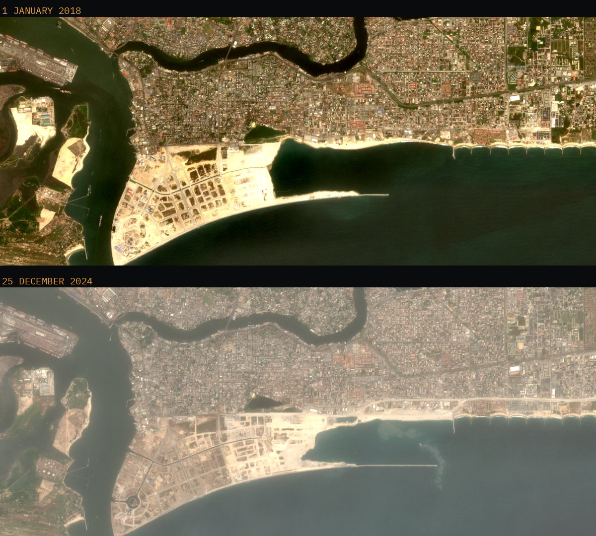
Scene S2B_31NEH_20180101 of 1 January 2018 and scene S2B_31NEH_20241225 of 25 December 2024, Level-2A surface reflectance, 10 metre bands B04, B03 and B02, retrieved from the open Sentinel-2 archive. Both crops cover the same ground, use the same reflectance stretch and the same gamma, and have had nothing added or removed. Atmospheric haze differs between the two days and has been left as it is.
https://dataspace.copernicus.eu/ ↗
The developer's account: the groynes were built by Lagos State to the east, and “Eko Atlantic and the groynes protect a combined 16km of Lagos coast”. The groyne field is visible in the satellite images on this page, as the row of scalloped bays running east.
https://www.ekoatlantic.com/blog/eko-atlantics-great-wall-of-lagos-passes-6km ↗
The state's own account: “A land concession agreement was executed between the Lagos state government and South Energyx Nig. Ltd in year 2006 to provide a permanent solution to the Lagos bar beach shoreline erosion in Victoria Island under public - private partnership arrangement.”
https://x.com/followlasg/status/1788888455524577407 ↗
“South Energyx Nigeria Ltd., a subsidiary of the Chagoury group, was specifically created to undertake the development.” The contractor named is China Communications Construction Group; the consultants are Royal Haskoning and ar+h Architects. Quartz describes the project as “the brainchild of the Chagoury brothers”, who own South Energyx.
https://en.wikipedia.org/wiki/Eko_Atlantic ↗
“Upon completion, the new peninsula is anticipating at least 250,000 residents and a daily flow of 150,000 commuters.” The figure originates with the developer. Quartz reports a different framing — 250,000 jobs rather than residents — and a 2026 report citing EnvironewsNigeria gives a design population of about 350,000.
https://en.wikipedia.org/wiki/Eko_Atlantic ↗
The report states that South EnergyX Nigeria Limited did not respond to requests for comment. A lawmaker approached about relocation and compensation, Noheem Babatunde Adams, declined and referred the reporter to the Ministry of Waterfronts.
https://saharareporters.com/2026/05/03/my-mothers-grave-ocean-how-surges-dredging-are-devouring-okun-alfa-lagos-disappearing ↗
Lagos State Climate Risk Assessment Comprehensive Report. In the executive summary: “It is worrisome to note that the popular Alfa beach … has today been lost to the Atlantic.” The same summary finds that features “especially the Alfa Beach axis, have the highest degree of vulnerability to the threat of ocean surge”. Commissioned with support from UNDP and C40; the contract was awarded in July 2020.
https://moelagos.gov.ng/wp-content/uploads/2021/09/Geo-Solutions-Lagos-CRA-Feb-Final-Report-V4-April-23-2021.pdf ↗
Adejat Murayo describes a surge at about 1 a.m. in 2009 taking the ten houses she inherited from her mother: “My mother's burial site is in the ocean. Everything is gone!” Olayinka Ajandi, an architect and indigenous landowner, says his father lost seven buildings, and sets out a timeline: “The first surge happened in 2009, and the ongoing Eko Atlantic City project started sand mining from the sea in 2008.” He states the sequence and stops short of stating a cause.
https://saharareporters.com/2026/05/03/my-mothers-grave-ocean-how-surges-dredging-are-devouring-okun-alfa-lagos-disappearing ↗
“I lost my palace. You can see that we just built this (new palace). The former palace is inside the ocean.” Sheriff Elegushi, a community leader, points out where a tarred road, electricity poles and a health centre stood, and says: “There is no more land for us to move to.” The reporter files from a point some 1,500 metres from where Alpha Beach used to be.
https://edition.cnn.com/2021/11/10/africa/lagos-okun-alfa-climate-crisis-intl-cmd ↗
“Eko Atlantic has given us a very serious problem.” And: “Some people built concrete block houses with many rooms but they are now sleeping in makeshift structures made with planks.”
https://edition.cnn.com/2021/11/10/africa/lagos-okun-alfa-climate-crisis-intl-cmd ↗
Chief Yusuf Olatunji Elegushi Atewolara, Baale of Okun Alfa, quoted saying “the government pumped sand to their own site (Eko Atlantic Project)”. He also says that since the dredging stopped, the surge has not returned. The same report quotes Sheriff Elegushi, a community leader, saying “That dredging weakened our land and allowed the ocean to erode it”, and describes a surge reaching the old building line the week before the reporter's visit. The two accounts are not reconciled in the report.
https://saharareporters.com/2026/05/03/my-mothers-grave-ocean-how-surges-dredging-are-devouring-okun-alfa-lagos-disappearing ↗
Jidah Saed: “When they started the breakers in 2011, the whole idea was to extend it by about 1,000 meters”, and “If they had finished it, then we would be safe.” Sheriff Elegushi: “The job was stopped. That’s why water is still penetrating. The government promised to do more. This was just half of it.” Another community leader, Tajudeen: “Without the breakers, there wouldn’t have been anyone left in this village.” A 2018 Lagos State statement described the construction as “a continuous project subject to availability of funds”.
https://edition.cnn.com/2021/11/10/africa/lagos-okun-alfa-climate-crisis-intl-cmd ↗
Asked about the communities’ claims, Frame said: “That’s not the case.” He said consultants designed the sea wall and the reclamation and “have monitored that progress from the beginning”, and that dredging contractors were kept beyond the Minus 15 Contour — “the point at which, if you dredge closer to the shoreline, you are going to affect the coastline”. His conclusion: “So the dredging operation has not caused any erosion on the coastline.”
https://edition.cnn.com/2021/11/10/africa/lagos-okun-alfa-climate-crisis-intl-cmd ↗
Alebiosu calls the erosion a natural challenge and asks what caused Victoria Island's erosion in the first place. He says illegal dredging happens mostly in the lagoon rather than the Atlantic. The report states that he acknowledged “the direct scientific link to specific projects remains debated”.
https://saharareporters.com/2026/05/03/my-mothers-grave-ocean-how-surges-dredging-are-devouring-okun-alfa-lagos-disappearing ↗
“The Lagos coast: Investigation of the long-term morphological impact of the Eko Atlantic City project”, Faculty of Civil Engineering and Geosciences, January 2012. The model result, in the author’s words: “the erosion of the Bar Beach is shifted eastward by the construction of the project”. This is a prediction from a coastline model, not a measurement of what later happened.
https://repository.tudelft.nl/record/uuid:794318f9-9279-4a3c-9030-2f9fab7c6562 ↗
From the abstract: “the total volume of erosion occurring downstream of the tidal inlet is not altered by the presence of the Eko Atlantic City project”. The coast east of the Commodore Channel was eroding before the project and would have continued to. What the model says changes is where that erosion lands and how fast it arrives.
https://repository.tudelft.nl/record/uuid:794318f9-9279-4a3c-9030-2f9fab7c6562 ↗
From the abstract: “the erosion rates directly downstream of the project are increased significantly” and “the erosion rates downstream Eko Atlantic City diminish rapidly”. Rates are highest just after construction and decrease over the years, while the length of coast affected grows. Alpha Beach is described as circa 6 km downstream of the project.
https://repository.tudelft.nl/record/uuid:794318f9-9279-4a3c-9030-2f9fab7c6562 ↗
The preface records that the study was initiated by Royal Haskoning, with Deltares involved in the modelling. Two members of the assessment committee are from Royal Haskoning: dr. ir. M. van Ledden and ir. C. Hoyng. Royal Haskoning are the marine engineering consultants on Eko Atlantic, and their managing director is quoted on the developer’s own site.
https://repository.tudelft.nl/record/uuid:794318f9-9279-4a3c-9030-2f9fab7c6562 ↗
For the Alpha Beach stretch the abstract states that “a nourishment volume in the order of the annual sediment transport can prevent erosion at this part of the coast”. The longshore transport used in the calculations is 600,000 cubic metres a year, which the thesis says is consistent with published values of 500,000 to 1,000,000. The thesis also records that none of the historical nourishments at Bar Beach had a permanent positive effect.
https://repository.tudelft.nl/record/uuid:794318f9-9279-4a3c-9030-2f9fab7c6562 ↗
The thesis assumes short-term phenomena average out over the long run, and does not explicitly model density currents, river seasonality, waves or storm surges. It defines long-term impact as “the impact occurring in the first ten years following construction of the project”, which is narrower than the 2060 horizon discussed elsewhere in it. Sediment input from the Ogun River is excluded as too crudely estimated, and the single-line theory assumes the beach profile keeps its shape.
https://repository.tudelft.nl/record/uuid:794318f9-9279-4a3c-9030-2f9fab7c6562 ↗
The sentence runs: “according to interaction with the various stakeholders during the field survey showed that” the Eko Atlantic City project “has exacerbated the rate of ocean surge”, with over 350 metres of the community’s land lost to the Atlantic. The same framing appears again: “Interaction with the community members showed that” displacement had been exacerbated by the project. In the pages we have read, the report nowhere states this as its own finding, and the 350 metres is not tied to a named community.
https://moelagos.gov.ng/wp-content/uploads/2021/09/Geo-Solutions-Lagos-CRA-Feb-Final-Report-V4-April-23-2021.pdf ↗
Reported from a Spaces for Change document. Set against the project's own dates, dredging from 2008 and wall construction from 2009, the approval lands four to five years after the work began. Spaces for Change and LEDAP argue the project proceeded without proper assessment; they do not claim it caused the erosion at Okun Alfa.
https://saharareporters.com/2026/05/03/my-mothers-grave-ocean-how-surges-dredging-are-devouring-okun-alfa-lagos-disappearing ↗
Reporting
Sponge Media
Editorial direction
Dayo Elegbe
Design and build
Sponge Media
Imagery
Contains modified Copernicus Sentinel data 2018 and 2024
Funding
Sponge Media. No sponsor.
Corrections and changes
- 9 Nov 2026 — First published.